A native bush escape 5km from downtown Wellington.
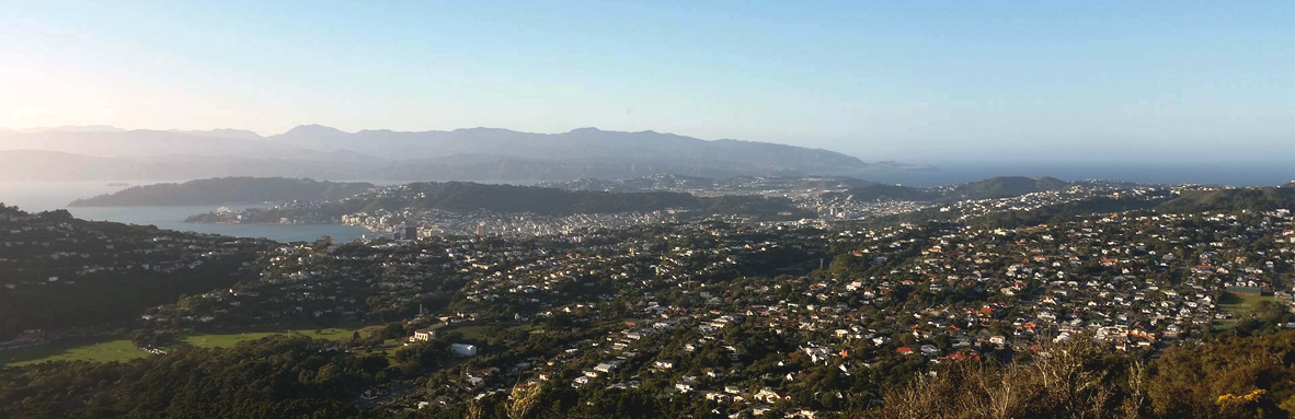
Otari-Wilton’s Bush is only 5km from the city centre but it feels like another world. The reserve contains quite a few different trails that wind their way along the river valley and up the hill through dense native bush. The tops of these trails join onto the Skyline Track and Johnston Hill, giving an excellent vantage point out to the harbour and past Karori to Makara Peak.
Did You Know?
- Otari-Wilton’s Bush is the only botanic garden in the country dedicated to New Zealand native plants.
- The reserve consists of 100 hectares of native forest, including an 800-year-old rimu and around 1,200 plant species from as far away as the Kermadec Islands.
- “Otari” means “place of snares”, because local Maori used to hunt birds there. These days you can spot a huge array of native birds in the reserve, including kakariki, kaka, tui and kereru.
Route Details
- Distance: About 9 kilometres, with options to shorten or lengthen
- Elevation: About 350m elevation gain and loss
- Difficulty: Mostly intermediate trails. There are some roots and the trails can be slippery after rain. The loop detailed here is probably the easiest route up the hill — the other trails tend to be steeper (many include steps) and more technical.
- Estimated time: About 50 minutes for speed demons, up to an hour and a half at a more relaxed pace
Start Point
For simplicity we started at the main entrance to Otari-Wilton’s Bush by the visitor centre car park on Wilton Road. This makes a convenient meeting point. You can also join this loop from the Karori cemetery (entrance on Old Karori Road) or the Skyline Track (multiple options).
Note: If you’re meeting people ensure you have the same carpark in mind — there’s a separate, smaller Otari-Wilton carpark at the northern end on Churchill Drive.
Directions
After entering the archway to Otari, hang a left and run past the visitor centre and over the canopy walk (a boardwalk up in the trees). At the end of the canopy walk, turn right and make your way down the hill. Before long you will emerge at Troup Picnic Lawn.
Take a left by the toilets and follow the trail along the stream until you come to a fork in the path where a small footbridge crosses the stream on your right. There will be a sign here pointing up to the cemetery. Take this right turn and make your way up to the cemetery (there is one fork along the way — both go to the cemetery but take the right hand trail to make navigation easier).
When you pop out at the cemetery, follow the road that snakes around the hill to the right. Stay on it for a few hundred metres until you spot a trail heading back into the bush on your right shortly before the road ends. Ignore the trail heading straight up to Johnston Hill (this will get you there, but it’s very steep — stick to the lower trail for a gentler ascent).
Keep heading up the hill for 10 minutes or so, following the signs to Skyline. Eventually you will come to a gate and cattle-stop with farmland on the other side. Cross the cattle-stop and follow the four wheel drive track for 100 metres or so until you meet the Skyline Track. It can get windy on the Skyline so now may be the time to reach for an extra layer on a cooler day.
Johnston Hill Detour
From here, if you want to go to Johnston Hill you will need to turn left. There are two options:
- Head straight up the hill to your left on an indistinct trail; or
- Follow Skyline to traverse around the hill before taking another sharp left to double back up the other side on a clearer path.
Either way, you will meet a trail up on the ridge with a sign pointing you out to Johnston Hill. Stop here and enjoy the view!
The Descent
From Johnston Hill, head back the way you came but carry on along Skyline past where you joined the trail originally. After a few hundred metres a four wheel drive track splits off Skyline to the right and heads down the hill.

Follow this for a couple more hundred metres (down then briefly up again), keeping an eye out for a trail on your right heading down the hill. This is Red Trail. Follow it straight down. You’ll come to the Flax Clearing, where you’ll want to veer left down the hill to stay on Red Trail until you emerge back in the valley by the stream.
Turn left and follow the trail to the end of the valley where it loops around and back up the hill. This will bring you back to the main entrance where you started.
Facilities
There isn’t much in Wilton itself, but there are gas BBQs at Troup Picnic Lawn if you want to bring your own supplies. Otherwise, it’s a short drive (or run, if you still have some juice in your legs) to cafes and pubs in Kelburn, Wadestown or Karori.
- One Fat Bird in Karori (Marsden Village) — craft brew and burger
- Kelburn Cafe — brunch fare
Toilets and water at two places in Otari:
- At the visitor centre just to the right of the main entrance on Wilton Road
- At Troup Picnic Lawn down in the valley
Transport: From town, a number 14 bus will drop you off a couple hundred metres from the main entrance to Otari. There is also a car park at the main entrance. Otherwise, it’s about a 5km run from the city through Northland, Tinakori Hill or Wadestown.
Options to Extend
We’ve described this loop clockwise, but it’s also good in the other direction. If you would like a shorter run, you can skip the detour to Johnston Hill (making it about 7km).
- South along Skyline: Head to Karori, or extend further by hopping across the road into the Makara Peak Mountain Bike Park
- North along Skyline: Head to the top of Mt Kaukau
- Lots of trails to explore in Otari and Johnston Hill reserve — check out the map at the entrance for inspiration or just follow your nose