Mt Matthews is the biggest peak in the Rimutaka range, standing majestically within view of Wellington city.
Did You Know?
- Kiwi: North Island brown kiwi were released into the area in 2006.
- Views: The views along the way add up to 360 degrees over the course of the climb: south to the south coast, west to Wellington City, north to the Wairarapa plains, east to Lake Ferry.
- Huts: There are a series of DoC huts along the banks of the Orongorongo river. These are well equipped, well maintained and a delight to camp in — especially if it means making a weekend out of the adventure.

Route Details
- Distance: About 27 kilometres return
- Elevation: 940 metres
- Difficulty: Intermediate to Advanced. Pack your gear sensibly. While you don’t need mountaineering equipment, you do need to plan and to tell people your plans.
- Estimated time: It is a long day climb of about 10 to 12 hours.
Before You Go
If you read one thing, let it be this: Be prepared. Plan your day carefully. Be happy to give up on the day you might have planned and try again another time, if the conditions aren’t right. The mountain will be there a long time. That said, when you do set off, be prepared and careful, so you will have a bloody beauty of a day out.
Gear
In your day pack: 2L of water, a long sleeved merino jumper, a survival blanket, a whistle, a mobile phone (no reception but available if needed). Combined: mixed nuts, dried fruit, chocolate, homemade bread/peanut butter, muesli bars, electrolyte tablets, and a lot of dense sugary food — energy gels, jelly beans, licorice.
Trail running shoes with good grip, merino socks, hat, sunglasses, sunscreen. If anything, overestimate how much food and water and gear you might need.
Start Point
Access is via the Rimutaka Forest Park Catchpool Valley carpark. This is about a 45 minute drive from Wellington city, via Petone and Wainuiomata. Catchpool Valley is 12km south of Wainuiomata — follow the Coast Road for 10km to the Rimutaka Forest Park entrance, then follow the Catchpool Valley road for 2km to the car park. Gates are open summer 6am to 8pm; winter 6am to 6pm.
The Route
The route breaks into four sections:
1. Orongorongo Track (5km)
An idyllic streamside track that weaves 5 kilometres from the carpark to the rainbow bridge of Turere Stream (where it meets the Orongorongo river). Gorgeous, cooling bush with an easy gravel pathway. Little ups and downs. Very runnable.

2. Orongorongo River (4km)
You’ll know you’ve joined the riverbed by the end of the rainbow bridge. You can choose to either walk on the river bed (4km) or on Big Bend Track (about 5km). The riverbed is pretty dry in summer — we chose to wade through sections getting wet feet rather than care too much about finding dry crossings.
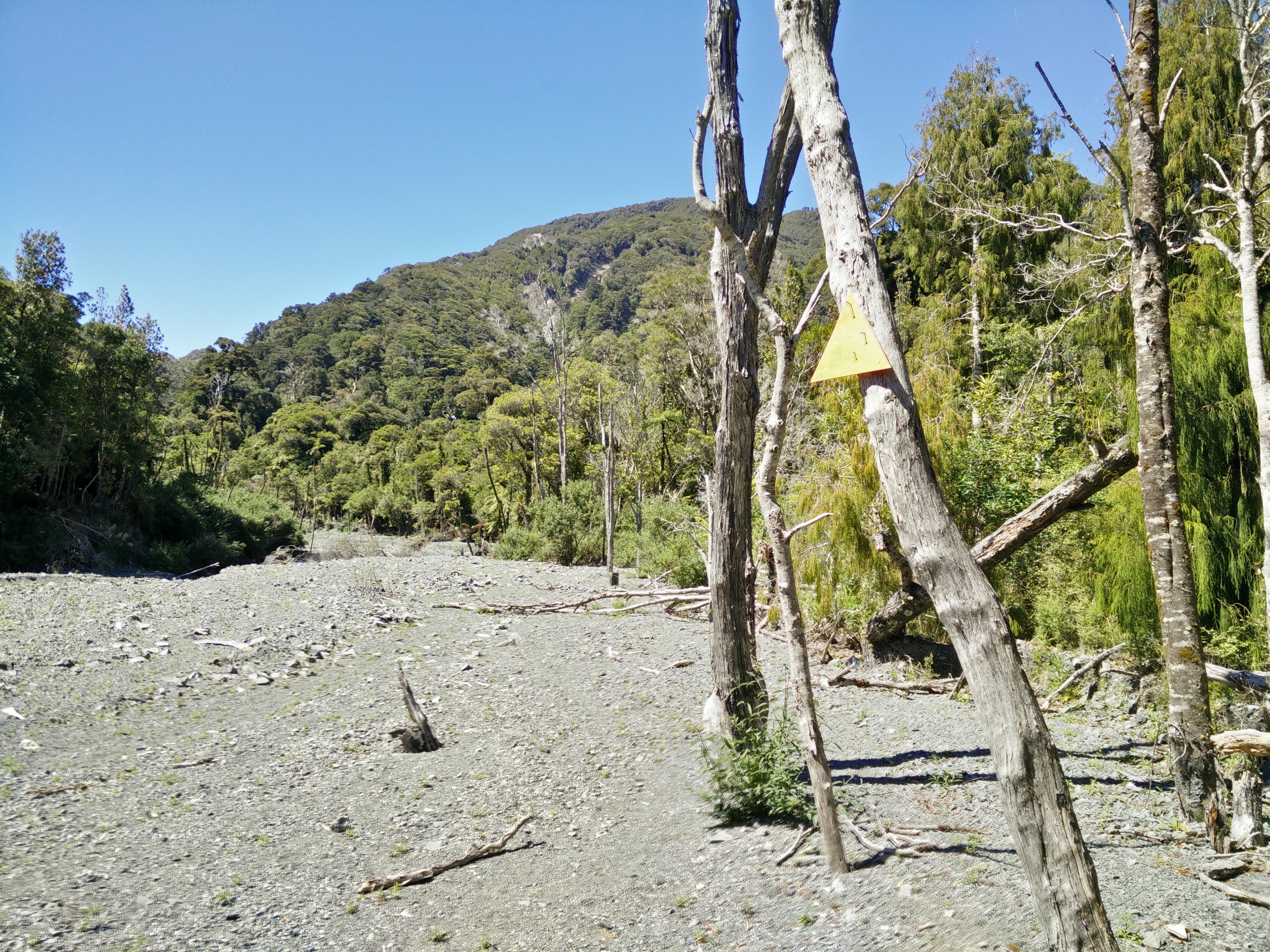
Critical navigation note: Keep a watchful eye on your right hand side / the south for a bright orange triangle affixed to a tree after you’ve been walking for 4km on the riverbed. Found the orange triangle? Congratulations! This is it! Do not keep walking up the river thinking that this wimpy triangle can’t possibly be it. Trust the triangle.
3. Mt Matthews Stream (600m)
Walk in 600 metres straight ahead along the Mt Matthews stream bed. On your right hand side, you’ll see another orange triangle. This takes you straight ahead into the bush where you then turn left. You will continue to see these triangles for the day. If you don’t see one for more than 30 seconds — look around, turn back, go to your last one, check in all directions.
4. Mt Matthews Track to Summit (4km)
This follows the stream bed for another few hundred metres before changing to gravelled and soil trail. Consider topping up your water stores here if you have iodine tablets.
The trail from here is 4 kilometres of up, up and some more up. It is well marked and also very steep in places, with a lot of tree roots and tricky surfaces. Take your time, stop every so often for a snack. Don’t underestimate the “4km” part — you’ll be climbing the entire 940m peak here.

The two most interesting stops are halfway up (a grassy knoll with views back to tiny, tiny Wellington through a gap in the mountain range) and the top. Before halfway you’ll pass a signed option off to the right to the South Saddle (about 15 minutes each way) and, should you choose, all the way to the coast (over 2 hours).
There are a series of false summits where you’ve gone up, then go down a little bit, then up again. Knowing and expecting this helps. When there are little lookouts on either side, take the opportunity — these are spectacular.


The summit view was beyond words. The sky had a hundred tones of blue which faded into each other before exploding into the green patchwork of the land.
The Return
Watch those ankles, step carefully, use your hands. Going down is harder than the up. Afford yourself little breaks to eat and keep drinking water. We walked the return via Big Bend Track (5km) rather than the riverbed again — a sweet little track alongside the river. Once back at the Orongorongo Track, slow-run back to the carpark.
Point to Point Distances
| Section | Distance |
|---|---|
| Orongorongo Track (carpark to Turere Bridge) | 5km |
| Orongorongo Riverbed (bridge to Matthews Stream) | 4km |
| Matthews Stream (first to second orange triangle) | 600m |
| Mt Matthews Summit (stream to summit) | 4km |
| Total return | ~27km |
Facilities
Carpark at Catchpool Valley with campsite, picnic tables, information boards and toilets. Check the DoC website for alerts and updates before you go.
Transport: You’ll need your own transport to get to Catchpool Valley.
Making a Weekend of It
One option is to stay a night or two in one of the Department of Conservation huts at the riverbed. Walk in along the Orongorongo Track, stay, then up and down Mt Matthews in a day, stay, then walk out the following day. There are other walks and swimming spots to make it a proper weekend adventure.